A Cheap Sailboat Autopilot WiFi Remote Using ESP32
Despite it is sold as a non-cartographic handled GPS device, with limited storage capacity of 10 MB and the inability to expand it, the eTrex 10 GPS, like almost all Garmin devices, is capable of reading Garmin maps in IMG format. However, the storage limitation prevents to use standard Garmin maps, which are hundreds of megabyte big, not well updated and expensive. We can overcome these limits by utilizing the vast resources of OpenStreetMap (OSM), a collaborative mapping project that empowers users to contribute and update maps themselves.
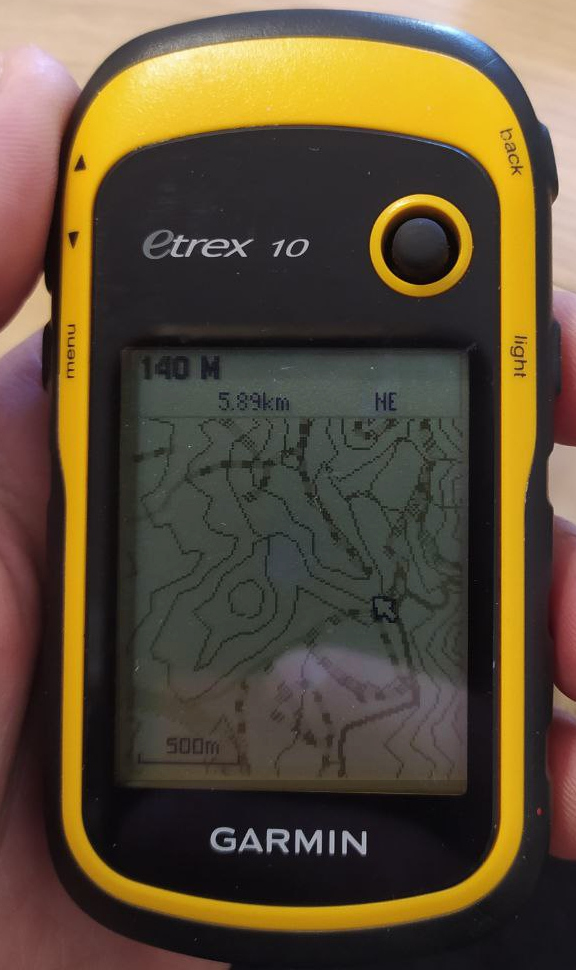
I’d like to advocate for the eTrex 10 by highlighting its compatibility with OSM maps, which can be a game-changer for outdoor enthusiasts and adventurers, at a fair price of around 90$. With just 5 MB of storage, I have been able to map out half of southern Sardinia, including contour lines, thanks to OpenStreetMap.
Now, let’s delve into two methods to integrate OpenStreetMap data into your Garmin device:
The easiest way to obtain Openstreetmap maps in Garmin format, is to use BBBike extractor service.
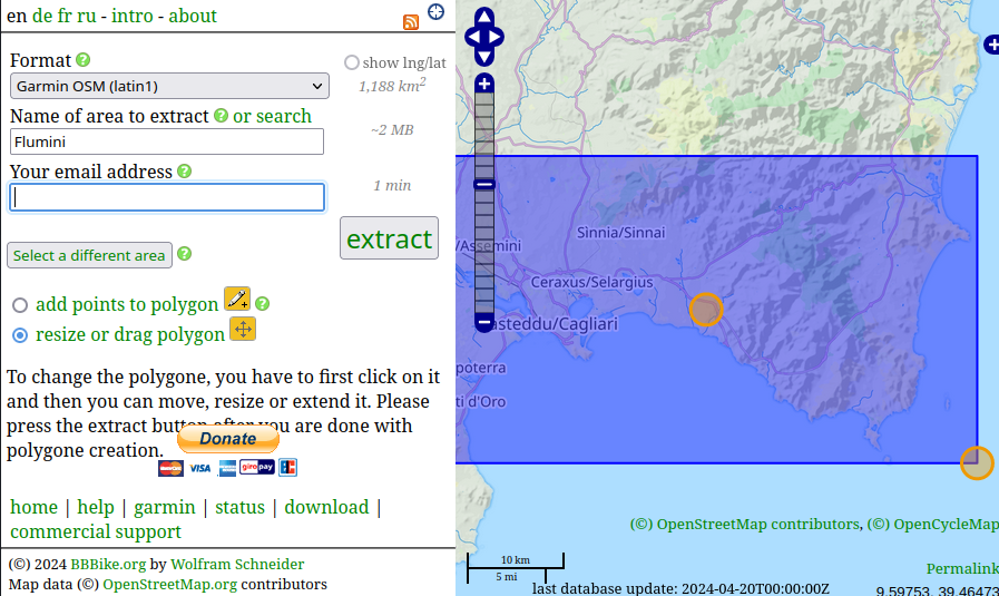
Within minutes, your map file will be ready for download. Some Garmin devices, such as the eTrex, require the map file to be named gmapsupp.img for compatibility.
For those who enjoy tinkering and want to optimize their maps further, manual customization is an option; this method allow for instance selecting only desidered OSM features, add contour lines, simplify tracks, etc.
Download roads and all OSM data for your area using Overpass-api services like overpass-api.de. You can select specific features, such as roads, trails, rivers, peaks, and notable points of interest like churches and railways.
First you need to define an osm-script containing your query; you can write it in XML or OverpassQL; use this wiki as reference: Overpass_API#Simple_usage_examples.
The most important thing you have to specify in the query is the bounding box of the area you want to download.
<osm-script timeout="900" element-limit="1073741824">
  <bbox-query s="51.15" w="7.0" n="51.35" e="7.3"/>
  <print/>
</osm-script>
After defining and saving your query, use wget or similar software in order to download osm data:
wget --post-file=your_query_file.xml -O map.osm http://overpass-api.de/api/interpreter
If you are going to use this map for outdoor sports, sometimes is useful to also have contour lines.
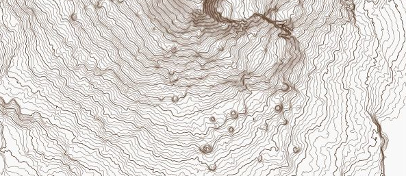
You can use Srtm2Osm to obtain an OSM file of digital elevation models for your area of interest.
Now that we have openstreetmap data files, we can use a tool named mkgmap in order to convert those file to a Garmin .img file.
This is the command I use, but it can customized with parameters in order to fit with your needs:
mkgmap --reduce-point-density=3 --gmapsupp --input-file=contour.osm --input-file=map.osm --merge-lines
--reduce-point-density: simplifies lines--gmapsupp: create a gmapsupp map file--merge-lines: try to merge straight linesNow copy the file to your device, using an appropriate name and it’s done.
Both methods are compatible with any Garmin device that supports the Garmin .img map format, ensuring you always have up-to-date maps at your fingertips. Whether you opt for the convenience of BBBike Extract or the customization of manual crafting, OpenStreetMap offers a wealth of possibilities for enhancing your outdoor adventures.
Have fun!
During my Quantum Computing journey, I often needed to simulate some quantum circuits; sometimes they are small, but some other times they are bigger enough ...
Despite it is sold as a non-cartographic handled GPS device, with limited storage capacity of 10 MB and the inability to expand it, the eTrex 10 GPS, like al...
Since the latest v0.1.18 version, the Qlasskit library offers two useful tool for circuit analysis and optimization.
In the last release of Qlasskit, I introduced a new feature able to export a qlassf function to a binary quadratic model (as bqm, qubo or ising model). This...
In early 2023, I embarked on a journey to explore the field of probabilistic computing. This endeavor culminated in the construction of a hardware prototype,...
Today, I’m going to show you how to use Qlasskit to create a quantum circuit able to search for Sudoku puzzle solutions.
In a recent article I wrote, “Quantum Computing on a Commodore 64 in 200 Lines of BASIC”, published both on Medium and Hackaday.com, shows a two-qubit quantu...
Traditionally, creating quantum circuits requires specialized knowledge in quantum programming. This requirement holds true when encoding a classical algorit...
In an age where companies are selling two-qubit quantum computers for a sum of money that would make your wallet recoil in horror, here we are, stepping off ...
This June I emerged as one of the top participants with 9 bounties collected (alongside another exceptional contributor) in the #UnitaryHack Hackathon, hoste...
A few days ago I came across a yt video discussing the ESA Copernicus program, a European initiative for monitoring earth via a satellite constellation. This...
Qiskit is a python SDK developed by IBM and allows everyone to create quantum circuits, simulate them locally and also run the quantum circuit on a real quan...
As someone noticed from the previous post, last weeks I started to write a new programming language for Tezos smart contracts. This project was initially int...
While writing a new programming language, it is often useful to write some real use-cases to test the syntax, the language expressiveness and the code cleann...
Documentation is like sex: when it is good, it is very, very good; and when it is bad, it is better than nothing
This is my new blog, based on jekyll. I’ll soon import old posts from my old blog.
Contractvm is a general-purpose decentralized framework based on blockchain. The framework allows to implement arbitrary decentralized applications in an eas...
Most of bitcoin dice software use a system to prove the fair play of the server for each bet. Most of them implement this mechanism using two seed (server se...
In the aim to merge two of my server on digitalocean, today I tried to write a mod_rewrite rule to redirect a secondary domain to a subfolder. After one hour...
MineML is a multithread CPU based bitcoin miner written in F#. At the moment it’s a slow implementation, but the class structure offers the possibility to im...